 |
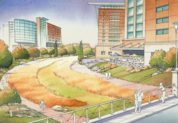
An artist’s rendering of the proposed drainage swale and recreation trail looking south from Farnam Street with UNMC research towers bordering on each side. |
The options were developed through a feasibility study conducted over the past year by HDR. The study was funded through a $1 million allocation from the 2006 Transportation Appropriations Bill and awarded to the Nebraska Department of Roads. It explored the possible realignment of Saddle Creek Road and considered the benefits and impact of the realignment on transportation, flood control, adjacent neighborhoods and area businesses.
Ralph Batenhorst, HDR’s project manager for the study, presented three options at the forum — one which would make no change to Saddle Creek Road and two which would make dramatic changes to the area immediately west of the UNMC campus.
The two new options were:
- Adding a drainage swale on the present location of Saddle Creek Road and then rebuilding Saddle Creek Road on the west side of the swale.
- Adding a drainage swale on the present location of Saddle Creek Road and then rebuilding Saddle Creek Road about one to one and a half blocks west of the present location. This option would allow for UNMC expansion contiguous to the campus with space for additional research towers just west of the swale.
|
“There is an existing storm sewer under Saddle Creek Road and that would remain,” Batenhorst said. “But the existing sewer does not have the capacity to handle major storms. The drainage swale would be located above the existing storm sewer and would accommodate the flow that the underground sewer cannot.”
The swale would begin just north of Dodge Street and generally follow the existing alignment of Saddle Creek Road, which is the alignment the original creek the street was named after used to take.
At Leavenworth Street, and at one or more additional locations, Batenhorst said detention areas would be created for storing storm water from the swale. The detention areas would then connect back into the existing storm sewer.
The benefits of the swale are two-fold. “It will reduce street flooding in an environmentally friendly manner,” Batenhorst said, “and it will provide green space with an opportunity for a recreational trail.”
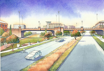 |
An artist’s rendering of the view from the north of a possible Dodge Street bridge going over a relocated Saddle Creek Road. |
Saddle Creek Road would take on a completely new look, possibly becoming more of a boulevard with two lanes of traffic in each direction, separated by a landscaped median, Batenhorst said. It could be up to 130 feet wide, which would allow for on street parking, bike lanes, wider sidewalks and more landscaping.
The swale and trail would create a distinctive space that would benefit both UNMC and the overall community, said Ken Hansen, assistant vice chancellor, UNMC Facilities Management & Planning.
“The swale and trail area will be quite scenic and would be a spectacular addition to midtown Omaha,” Hansen said “It would create an open space that would allow pedestrians, bikers and skaters to navigate safely under the busy streets above. It also would provide a much better link to the areas north and south of Dodge Street for all users.
“I liken it to the Riverfront Development project in downtown Omaha. It won’t happen overnight. It could take 20 years. But, when it is done, people will look back and realize how visionary it was.”
Jim Champion, chairman of the Destination Midtown board, agreed. “We see this as a once-in-a-lifetime opportunity,” he said. “It would benefit much of the Destination Midtown area. It’s not just about the medical center.”
Engineers determined that the best access to Dodge Street from Saddle Creek Road would be indirectly through access roads branching off Saddle Creek from the four different quadrants surrounding the two roads.
The estimated construction cost for rebuilding Saddle Creek Road on its existing alignment is estimated to be about $18 million, while rebuilding on a new alignment is estimated to cost about $1 million more, Batenhorst said.
“There obviously are going to be impacts to properties if either one of the alternatives is constructed,” he said.
Right-of-way acquisitions and relocation costs for rebuilding Saddle Creek Road on its existing alignment are expected to be in the range of $17 million to $20 million and in the range of $21 million to $24 million for rebuilding on a new alignment.
It’s estimated that either of the options could serve as a catalyst for potential redevelopment in the midtown area of between $250 million and $350 million, said Ron Schaefer, director for facilities planning and construction at UNMC.
“The redevelopment figures are on par with what is anticipated with the new Midtown Crossing area under construction just east of Mutual of Omaha,” Schaefer said. “Combined, the two projects would provide a huge economic boost to midtown Omaha. It will make midtown Omaha a great place to live and work and will truly make it a destination location.”
The next step, Batenhorst said, is to assimilate all the input from the public and do an environmental study of the two alternatives and identify the preferred alternative. This will take probably between 6 to 9 months. Once the environmental study is completed, a recommendation for the preferred alternative would be made.
“The study has determined that the project is feasible and has merit,” Batenhorst said. “All three alternatives need to be evaluated further and more public input is needed.”
The initial federal funding will cover the first phase of the feasibility study and the environmental study, he said. Additional federal funds are anticipated later this year to cover the preliminary and final design during 2008-09. Funding still needs to be identified for the right-of-way acquisition and construction that will take place in 2010 and beyond.
Those in attendance at the public forum were able to ask questions following the presentation.
To provide input on the project, people can send an e-mail to saddlecreek@hdrinc.com or go to the project information pages on the Destination Midtown and City of Omaha Web sites. As the project continues through the environment study phase, it is anticipated that additional public forums will be held to solicit more input.
Participants in the study included UNMC, The Nebraska Medical Center, the City of Omaha, Papio-Missouri River Natural Resources District, and the Nebraska Department of Roads.